 |
| Prof. Brian Gunter |
A satellite currently under development by Prof. Brian Gunter’s research group has just been guaranteed a NASA-supported launch sometime in the next three years.
On Feb. 17, NASA announced that Gunter’s Tethering And Ranging mission of the Georgia Institute of Technology (TARGIT) is one of 34 small satellites chosen for the agency’s latest Cubesat Launch Initiative (CSLI). The TARGIT nanosatellite will ‘hitch a ride’ into space as a secondary payload aboard one of NASA’s already scheduled missions in 2018, 2019 or 2020. Once in orbit, the 5-kilogram nanosat will begin its mission operations, which will test the accuracy of a miniaturized altimetry system.
CubeSats are cube-shaped satellites, where one spacecraft “unit” (1U) measures about four inches on each side, has a volume of about one quart, and weighs less than three pounds. Packed with miniaturized scientific equipment, they are increasingly seen as a cost-effective means of expanding the reach of traditional space missions. To date, the CSLI has launched 152 cubesats from 38 states.
The solar-powered TARGIT will be a 3U CubeSat that will house a compact laser altimetry system capable of delivering accurate topographic data (down to the centimeter) from as far away as 10 kilometers. Supported by a $200,000 grant from NASA's Undergraduate Student Instrument Program (USIP), Gunter’s team of 30 grad and undergrad researchers is currently wrapping up the preliminary design phase of the mission, where a prototype of TARGIT will be produced. By the end of the spring semester, he predicts, students will have used the Aero Maker Space studio to produce many of the components for the first prototype.
“Our aim, ultimately, is to be able to use the compact LiDAR imaging instrument we’re developing to map the topography of planetary bodies like moons and asteroids," says Gunter, who also heads up the RANGE cubesat project that is scheduled to launch in the fall of 2017.
“Right now, we have altimeters orbiting Earth that are capable of much higher accuracy, but they are full-sized spacecraft that cost hundreds of millions of dollars to build and launch. To put these larger altimeters on a planetary mission costs even more, so we’re looking for ways in which the size, weight and power of these instruments can be reduced without sacrificing too much performance.”
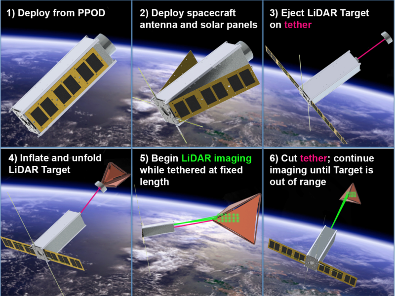
Once TARGIT is launched into space, it will deploy a small inflatable on a tether and create a 3D image of the target using the miniaturized LiDAR imaging camera. Because the inflatable's size and reflectivity will already be well-known, this will give engineers a chance to test the camera’s accuracy. Eventually, the tether will be cut and the satellite will use its precise pointing and tracking capabilities to continue capturing images of the inflated target as it drifts farther and farther from the satellite. This final phase is intended to represent a flyby scenario in a traditional space mission, where the topography of a comet, asteroid, or specific surface location is the desired target..
“The idea is to launch these compact altimeters on cubesats as a part of larger planetary missions so that they can gather data that we’ll need for future missions. For example, if we’re already sending a mission to Mars – which are planned for 2020 and 2022 - we can kick off some cubesats to investigate the surface of Phobos or Deimos along the way. That maximizes the science return of our planetary missions. For an extra 20 kilos of weight, we are able to do some high-risk, high-reward science – something we wouldn’t want to risk with a larger, more expensive spacecraft.”
The TARGIT mission is a joint project with GTRI and the School of Earth and Atmospheric Sciences.
 |
| This schematic depicts the various stages of TARGIT's mission, which will take place sometime between 2018 and 2020. Prof. Gunter's team of researchers is currently working up the necessary prototypes to enable some bench demonstrations. |